 Poland
| Local Name: | PLRzeczpospolita Polska |
|---|---|
| Capital: | Warsaw |
| ISO2: | PL |
| ISO3: | POL |
| Emoji: | 🇵🇱 |
| Population: | 37,836,252 |
| Languages: | PL Polish |
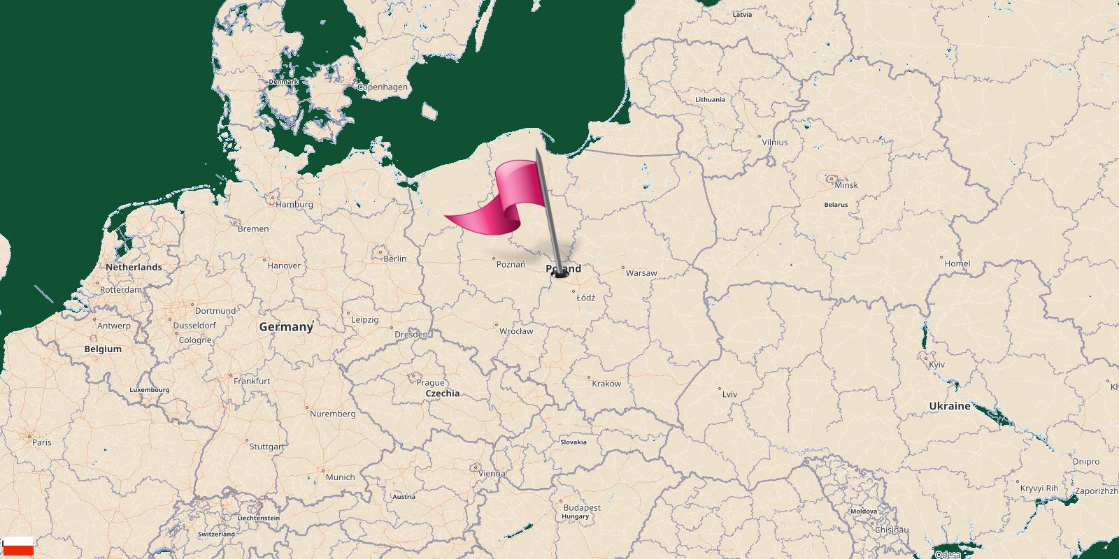
Location
Poland is a country located in Eastern Europe.
| Continent: | Europe |
|---|---|
| Region: | Europe |
| Sub Region: | Eastern Europe › Europe & Central Asia |
| Area: | 312,683.00 Square Kilometers 194,333.75 Square Miles |
| Share of world land: | 0.210808% |
| Share of Europe land: | 3.071542% |
| Geographic Coordinates: | 52°0'N, 19°0'N |
| Latitude: | 52.0 |
| Longitude: | 19.0 |
Share of world land
Share of Europe land
The countries border Poland
Poland shares its borders with 7 neighbouring countries.Those countries are listed in the table below with their direction from the center of Poland.
| Border Country | Degree | Direction |
|---|---|---|
| Russia | 69.14230733995° | East Northeast |
| Germany | 259.87946242715° | West |
| Belarus | 74.398679764562° | East Northeast |
| Ukraine | 109.94905652351° | East Southeast |
| Czech Republic | 217.1987034665° | Southwest |
| Slovakia | 168.03432281159° | South Southeast |
| Lithuania | 42.819815984235° | Northeast |
Cities Of Poland
- 🖈Aleksandrów Kuj...
- 🖈Aleksandrów Łód...
- 🖈Alwernia
- 🖈Andrychów
- 🖈Annopol
- 🖈Babimost
- 🖈Baborów
- 🖈Baranów Sandomi...
- 🖈Barcin
- 🖈Barczewo
- 🖈Bardo
- 🖈Barlinek
- 🖈Barwice
- 🖈Bełżyce
- 🖈Biała
- 🖈Biała Piska
- 🖈Biała Rawska
- 🖈Białobrzegi
- 🖈Biały Bór
- 🖈Białystok
- 🖈Biecz
- 🖈Bielawa
- 🖈Bielsko-Biała
- 🖈Bierutów
- 🖈Bieżuń
- 🖈Biskupiec
- 🖈Bisztynek
- 🖈Blachownia
- 🖈Błaszki
- 🖈Błażowa
- 🖈Błonie
- 🖈Bobolice
- 🖈Bobowa
- 🖈Bodzentyn
- 🖈Bogatynia
- 🖈Boguchwała
- 🖈Bojanowo
- 🖈Bolimów
- 🖈Bolków
- 🖈Borek Wielkopol...
- 🖈Borne Sulinowo
- 🖈Brok
- 🖈Brusy
- 🖈Brwinów
- 🖈Brzeg Dolny
- 🖈Brześć Kujawski
- 🖈Brzesko
- 🖈Brzeszcze
- 🖈Brzostek
- 🖈Brzozów
- 🖈Budzyń
- 🖈Buk
- 🖈Busko-Zdrój
- 🖈Bychawa
- 🖈Byczyna
- 🖈Bydgoszcz
- 🖈Bystrzyca Kłodz...
- 🖈Bytom
- 🖈Bytom Odrzański
- 🖈Bytów
- 🖈Cedynia
- 🖈Cegłów, powiat ...
- 🖈Chęciny
- 🖈Chełm
- 🖈Chełmek
- 🖈Chmielnik
- 🖈Chocianów
- 🖈Chociwel
- 🖈Chocz
- 🖈Chodecz
- 🖈Chojna
- 🖈Choroszcz
- 🖈Chorzele
- 🖈Chorzów
- 🖈Choszczno
- 🖈Chrzanów
- 🖈Ciechanowiec
- 🖈Cieszanów
- 🖈Ciężkowice
- 🖈Ćmielów
- 🖈Cybinka
- 🖈Czaplinek
- 🖈Czarna Białosto...
- 🖈Czarne
- 🖈Czchów
- 🖈Czechowice-Dzie...
- 🖈Czempiń
- 🖈Czerniejewo
- 🖈Czersk
- 🖈Czerwieńsk
- 🖈Czerwińsk nad W...
- 🖈Czerwionka-Lesz...
- 🖈Częstochowa
- 🖈Człopa
- 🖈Czyżew
- 🖈Dąbie
- 🖈Dąbrowa Białost...
- 🖈Dąbrowa Górnicz...
- 🖈Dąbrowa Tarnows...
- 🖈Daleszyce
- 🖈Dębno
- 🖈Debrzno
- 🖈Dobczyce
- 🖈Dobiegniew
- 🖈Dobra
- 🖈Dobra, powiat t...
- 🖈Dobre Miasto
- 🖈Dobrodzień
- 🖈Dobrzany
- 🖈Dobrzyca
- 🖈Dobrzyń nad Wis...
- 🖈Dolsk
- 🖈Drawno
- 🖈Drawsko Pomorsk...
- 🖈Drezdenko
- 🖈Drobin
- 🖈Drohiczyn
- 🖈Drzewica
- 🖈Dukla
- 🖈Działoszyce
- 🖈Działoszyn
- 🖈Dzierzgoń
- 🖈Dziwnów
- 🖈Elbląg
- 🖈Frampol
- 🖈Frombork
- 🖈Gąbin
- 🖈Gdańsk
- 🖈Gdynia
- 🖈Glinojeck
- 🖈Gliwice
- 🖈Głogów Małopols...
- 🖈Głogówek
- 🖈Głubczyce
- 🖈Głuchołazy
- 🖈Głuszyca
- 🖈Gniew
- 🖈Gniewkowo
- 🖈Gniezno
- 🖈Gogolin
- 🖈Gołańcz
- 🖈Golczewo
- 🖈Gołdap
- 🖈Goleniów
- 🖈Golina
- 🖈Goniądz
- 🖈Góra
- 🖈Góra Kalwaria
- 🖈Górzno
- 🖈Gorzów Śląski
- 🖈Gorzów Wielkopo...
- 🖈Gościno
- 🖈Gostyń
- 🖈Grabów nad Pros...
- 🖈Grodków
- 🖈Grodzisk Mazowi...
- 🖈Grodzisk Wielko...
- 🖈Grójec
- 🖈Grudziądz
- 🖈Gryfice
- 🖈Gryfino
- 🖈Gryfów Śląski
- 🖈Halinów
- 🖈Iłowa
- 🖈Iłża
- 🖈Inowrocław
- 🖈Ińsko
- 🖈Iwaniska
- 🖈Iwonicz-Zdrój
- 🖈Izbica Kujawska
- 🖈Jabłonowo Pomor...
- 🖈Janikowo
- 🖈Janów Lubelski
- 🖈Janowiec Wielko...
- 🖈Jaraczewo, Jaro...
- 🖈Jarocin
- 🖈Jasień
- 🖈Jastarnia
- 🖈Jastrowie
- 🖈Jastrzębie-Zdró...
- 🖈Jaworzno
- 🖈Jaworzyna Śląsk...
- 🖈Jedlicze
- 🖈Jędrzejów
- 🖈Jedwabne
- 🖈Jelcz-Laskowice
- 🖈Jelenia Góra
- 🖈Jeziorany
- 🖈Józefów nad Wis...
- 🖈Jutrosin
- 🖈Kalisz
- 🖈Kalisz Pomorski
- 🖈Kałuszyn
- 🖈Kalwaria Zebrzy...
- 🖈Kamień Krajeńsk...
- 🖈Kamieńsk
- 🖈Kamionka
- 🖈Kańczuga
- 🖈Kargowa
- 🖈Karlino
- 🖈Karpacz
- 🖈Katowice
- 🖈Kąty Wrocławski...
- 🖈Kazimierz Dolny
- 🖈Kazimierza Wiel...
- 🖈Kcynia
- 🖈Kędzierzyn-Koźl...
- 🖈Kępice
- 🖈Kępno
- 🖈Kęty
- 🖈Kielce
- 🖈Kietrz
- 🖈Kisielice
- 🖈Kłecko
- 🖈Kleczew
- 🖈Kleszczele
- 🖈Kłobuck
- 🖈Kłodawa
- 🖈Kłodzko
- 🖈Kluczbork
- 🖈Knyszyn
- 🖈Kobylin
- 🖈Kock
- 🖈Kołaczyce
- 🖈Kolbuszowa
- 🖈Kołobrzeg
- 🖈Kolonowskie
- 🖈Koluszki
- 🖈Koniecpol
- 🖈Konin
- 🖈Końskie
- 🖈Konstancin-Jezi...
- 🖈Koprzywnica
- 🖈Korfantów
- 🖈Kórnik
- 🖈Koronowo
- 🖈Korsze
- 🖈Kosów Lacki
- 🖈Kostrzyn
- 🖈Koszalin
- 🖈Kowalewo Pomors...
- 🖈Kozienice
- 🖈Koźle
- 🖈Koźmin Wielkopo...
- 🖈Kożuchów
- 🖈Krajenka
- 🖈Kraków
- 🖈Krapkowice
- 🖈Krasnobród
- 🖈Krobia
- 🖈Krośniewice
- 🖈Krosno
- 🖈Krosno Odrzańsk...
- 🖈Krotoszyn
- 🖈Kruszwica
- 🖈Krynica-Zdrój
- 🖈Krynki
- 🖈Krzanowice
- 🖈Krzepice
- 🖈Krzeszowice
- 🖈Krzywiń
- 🖈Krzyż Wielkopol...
- 🖈Książ Wielkopol...
- 🖈Kunów
- 🖈Kuźnia Racibors...
- 🖈Łabiszyn
- 🖈Lądek-Zdrój
- 🖈Łapy
- 🖈Łasin
- 🖈Łask
- 🖈Łaszczów
- 🖈Łazy
- 🖈Łeba
- 🖈Łęczna
- 🖈Legnica
- 🖈Lesko
- 🖈Leśna
- 🖈Leśnica
- 🖈Leszno
- 🖈Lewin Brzeski
- 🖈Libiąż
- 🖈Lidzbark
- 🖈Lipiany
- 🖈Lipsk
- 🖈Łobez
- 🖈Łobżenica
- 🖈Łochów
- 🖈Łódź
- 🖈Łomianki
- 🖈Łomża
- 🖈Łosice
- 🖈Lubawka
- 🖈Lubień Kujawski
- 🖈Lublin
- 🖈Lubniewice
- 🖈Lubomierz
- 🖈Lubraniec
- 🖈Lubsko
- 🖈Lutomiersk
- 🖈Lututów
- 🖈Lwówek
- 🖈Lwówek Śląski
- 🖈Maków Mazowieck...
- 🖈Maków Podhalańs...
- 🖈Małogoszcz
- 🖈Małomice
- 🖈Margonin
- 🖈Maszewo
- 🖈Miastko
- 🖈Michałowo
- 🖈Miechów
- 🖈Międzybórz
- 🖈Międzychód
- 🖈Międzylesie
- 🖈Międzyrzecz
- 🖈Międzyzdroje
- 🖈Miejska Górka
- 🖈Mieroszów
- 🖈Mieszkowice
- 🖈Mikołajki
- 🖈Mikołów
- 🖈Mikstat
- 🖈Miłakowo
- 🖈Milicz
- 🖈Miłomłyn
- 🖈Miłosław
- 🖈Mirosławiec
- 🖈Mirsk
- 🖈Młynary
- 🖈Modrzejów
- 🖈Mogielnica
- 🖈Mogilno
- 🖈Mońki
- 🖈Morąg
- 🖈Mordy
- 🖈Moryń
- 🖈Mosina
- 🖈Mrocza
- 🖈Mrozy, Mińsk Co...
- 🖈Mszczonów
- 🖈Murowana Goślin...
- 🖈Muszyna
- 🖈Myślenice
- 🖈Myślibórz
- 🖈Myszyniec
- 🖈Nakło nad Notec...
- 🖈Nałęczów
- 🖈Namysłów
- 🖈Narol
- 🖈Nasielsk
- 🖈Nekla
- 🖈Nidzica
- 🖈Niemcza
- 🖈Niemodlin
- 🖈Niepołomice
- 🖈Nisko
- 🖈Nowa Dęba
- 🖈Nowa Sarzyna
- 🖈Nowa Słupia
- 🖈Nowe
- 🖈Nowe Brzesko
- 🖈Nowe Miasteczko
- 🖈Nowe Miasto
- 🖈Nowe Miasto nad...
- 🖈Nowe Skalmierzy...
- 🖈Nowe Warpno
- 🖈Nowogard
- 🖈Nowogród
- 🖈Nowogród Bobrza...
- 🖈Nowogrodziec
- 🖈Nowy Dwór Gdańs...
- 🖈Nowy Korczyn
- 🖈Nowy Sącz
- 🖈Nowy Staw
- 🖈Nowy Tomyśl
- 🖈Nowy Wiśnicz
- 🖈Nysa
- 🖈Oborniki
- 🖈Oborniki Śląski...
- 🖈Odolanów
- 🖈Ogrodzieniec
- 🖈Okonek
- 🖈Olecko
- 🖈Olesno
- 🖈Oleszyce
- 🖈Olkusz
- 🖈Olsztyn
- 🖈Olsztynek
- 🖈Olszyna
- 🖈Opalenica
- 🖈Opatów
- 🖈Opatówek
- 🖈Opatowiec
- 🖈Opoczno
- 🖈Opole
- 🖈Opole Lubelskie
- 🖈Orneta
- 🖈Osieczna
- 🖈Ośno Lubuskie
- 🖈Ostrołęka
- 🖈Ostroróg
- 🖈Ostrów Lubelski
- 🖈Ostrzeszów
- 🖈Otmuchów
- 🖈Otyń
- 🖈Ożarów
- 🖈Ożarów Mazowiec...
- 🖈Ozimek
- 🖈Pacanów
- 🖈Paczków
- 🖈Pajęczno
- 🖈Pakość
- 🖈Parczew
- 🖈Pasłęk
- 🖈Pasym
- 🖈Pełczyce
- 🖈Pelplin
- 🖈Piaseczno
- 🖈Piaski
- 🖈Piekary Śląskie
- 🖈Pieniężno
- 🖈Pieńsk
- 🖈Pierzchnica
- 🖈Pilawa
- 🖈Pilica
- 🖈Pilzno
- 🖈Piotrków Kujaws...
- 🖈Piotrków Trybun...
- 🖈Pisz
- 🖈Piwniczna-Zdrój
- 🖈Pleszew
- 🖈Płock
- 🖈Płoty
- 🖈Pniewy
- 🖈Pobiedziska
- 🖈Poddębice
- 🖈Pogorzela
- 🖈Połaniec
- 🖈Polanów
- 🖈Połczyn-Zdrój
- 🖈Police
- 🖈Polkowice
- 🖈Poniatowa
- 🖈Poniec
- 🖈Poznań
- 🖈Prabuty
- 🖈Praszka
- 🖈Prochowice
- 🖈Prószków
- 🖈Proszowice
- 🖈Pruchnik
- 🖈Prudnik
- 🖈Prusice
- 🖈Pruszcz
- 🖈Przecław
- 🖈Przedbórz
- 🖈Przedecz
- 🖈Przemków
- 🖈Przemyśl
- 🖈Przysucha
- 🖈Pszczyna
- 🖈Pułtusk
- 🖈Pyrzyce
- 🖈Pyzdry
- 🖈Rabka-Zdrój
- 🖈Radków
- 🖈Radłów
- 🖈Radom
- 🖈Radomyśl Wielki
- 🖈Radzymin
- 🖈Radzyń Chełmińs...
- 🖈Rajgród
- 🖈Rakoniewice
- 🖈Raszków
- 🖈Rawicz
- 🖈Recz
- 🖈Resko
- 🖈Reszel
- 🖈Rogoźno
- 🖈Ropczyce
- 🖈Różan
- 🖈Ruciane-Nida
- 🖈Ruda Śląska
- 🖈Rudnik nad Sane...
- 🖈Rybnik
- 🖈Rychwał
- 🖈Rydzyna
- 🖈Ryglice
- 🖈Ryki
- 🖈Rymanów
- 🖈Ryn
- 🖈Rypin
- 🖈Rzepin
- 🖈Rzeszów
- 🖈Rzgów
- 🖈Ścinawa
- 🖈Sędziszów
- 🖈Sędziszów Małop...
- 🖈Sępólno Krajeńs...
- 🖈Sępopol
- 🖈Serock
- 🖈Sianów
- 🖈Siechnice
- 🖈Siedlce
- 🖈Siemianowice Śl...
- 🖈Sieniawa
- 🖈Sieraków
- 🖈Skała
- 🖈Skalbmierz
- 🖈Skarszewy
- 🖈Skaryszew
- 🖈Skawina
- 🖈Skępe
- 🖈Skierniewice
- 🖈Skoczów
- 🖈Skoki
- 🖈Skwierzyna
- 🖈Sława
- 🖈Ślesin
- 🖈Słomniki
- 🖈Słubice
- 🖈Słupsk
- 🖈Śmigiel
- 🖈Sobótka
- 🖈Sochocin
- 🖈Sokółka
- 🖈Sokołów Małopol...
- 🖈Solec Kujawski
- 🖈Sompolno
- 🖈Sopot
- 🖈Sośnicowice
- 🖈Sosnowiec
- 🖈Śrem
- 🖈Środa Śląska
- 🖈Środa Wielkopol...
- 🖈Stąporków
- 🖈Stary Sącz
- 🖈Staszów
- 🖈Stawiski
- 🖈Stawiszyn
- 🖈Stęszew
- 🖈Stronie Śląskie
- 🖈Strumień
- 🖈Stryków
- 🖈Strzegom
- 🖈Strzelce Krajeń...
- 🖈Strzelce Opolsk...
- 🖈Strzelin
- 🖈Strzelno
- 🖈Strzyżów, Subca...
- 🖈Suchań
- 🖈Suchedniów
- 🖈Suchowola
- 🖈Sulechów
- 🖈Sulęcin
- 🖈Sulejów
- 🖈Sułkowice
- 🖈Supraśl
- 🖈Suraż
- 🖈Susz
- 🖈Suwałki
- 🖈Swarzędz
- 🖈Świątniki Górne
- 🖈Świdnica
- 🖈Świebodzin
- 🖈Świecie
- 🖈Świerzawa
- 🖈Świętochłowice
- 🖈Syców
- 🖈Szadek
- 🖈Szamocin
- 🖈Szamotuły
- 🖈Szczawnica
- 🖈Szczebrzeszyn
- 🖈Szczecin
- 🖈Szczekociny
- 🖈Szczucin
- 🖈Szczuczyn
- 🖈Szczytna
- 🖈Szepietowo
- 🖈Szlichtyngowa
- 🖈Szprotawa
- 🖈Sztum
- 🖈Szubin
- 🖈Szydłów
- 🖈Szydłowiec
- 🖈Tarczyn
- 🖈Tarnobrzeg
- 🖈Tarnogród
- 🖈Tłuszcz
- 🖈Tolkmicko
- 🖈Toruń
- 🖈Torzym
- 🖈Toszek
- 🖈Trzcianka
- 🖈Trzciel
- 🖈Trzcińsko-Zdrój
- 🖈Trzebiatów
- 🖈Trzebinia
- 🖈Trzebnica
- 🖈Trzemeszno
- 🖈Tuchola
- 🖈Tuchów
- 🖈Tuczno
- 🖈Tuliszków
- 🖈Tuszyn
- 🖈Twardogóra
- 🖈Tychowo
- 🖈Tychy
- 🖈Tyczyn
- 🖈Tykocin
- 🖈Tyszowce
- 🖈Ujazd
- 🖈Ujście
- 🖈Ulanów
- 🖈Uniejów
- 🖈Urzędów
- 🖈Ustrzyki Dolne
- 🖈Wąchock
- 🖈Wadowice
- 🖈Wałbrzych
- 🖈Warka
- 🖈Warsaw
- 🖈Warta
- 🖈Wasilków
- 🖈Wąsosz
- 🖈Węgliniec
- 🖈Węgorzewo
- 🖈Węgorzyno
- 🖈Wiązów
- 🖈Więcbork
- 🖈Wieleń
- 🖈Wielichowo
- 🖈Wieliczka
- 🖈Wieluń
- 🖈Wieruszów
- 🖈Wilamowice
- 🖈Wiskitki
- 🖈Wiślica
- 🖈Witkowo
- 🖈Witnica
- 🖈Wleń
- 🖈Włocławek
- 🖈Włoszczowa
- 🖈Wojnicz
- 🖈Wolbórz
- 🖈Wolbrom
- 🖈Wołczyn
- 🖈Wolin
- 🖈Wołomin
- 🖈Wołów
- 🖈Wolsztyn
- 🖈Woźniki
- 🖈Wronki
- 🖈Września
- 🖈Wschowa
- 🖈Wyrzysk
- 🖈Wyśmierzyce
- 🖈Wysoka
- 🖈Wyszków
- 🖈Wyszogród
- 🖈Ząbkowice Śląsk...
- 🖈Zabłudów
- 🖈Żabno
- 🖈Zabrze
- 🖈Zagórów
- 🖈Zagórz
- 🖈Zagórze, Sosnow...
- 🖈Zakliczyn
- 🖈Zaklików
- 🖈Zakroczym
- 🖈Zalewo
- 🖈Zamość
- 🖈Żarki
- 🖈Żarów
- 🖈Zator
- 🖈Zawadzkie
- 🖈Zawichost
- 🖈Zbąszyń
- 🖈Zbąszynek
- 🖈Zduny
- 🖈Zdzieszowice
- 🖈Żelechów
- 🖈Zelów
- 🖈Żerków
- 🖈Ziębice
- 🖈Zielona Góra
- 🖈Złocieniec
- 🖈Złoczew
- 🖈Złoty Stok
- 🖈Żmigród
- 🖈Żnin
- 🖈Żory
- 🖈Żukowo
- 🖈Żuromin
- 🖈Zwierzyniec
- 🖈Zwoleń
- 🖈Żychlin
- 🖈Żywiec